

Piri Reis, also known as Ahmed Muhiddin Piri, was a senior naval officer of the Ottoman Empire. He was a geographer as well as a cartographer. He is most known today for his charts and maps, which appear in his masterpiece ‘Kitab-Bhriye’ (Book of Navigation). It contains complete navigational data as well as detailed charts from the historical period illuminating important cities and ports in the Mediterranean Sea. In 1513, he drew his first globe map, of which only about a third has survived. It was discovered in Istanbul’s Topkapi Palace in 1929, earning him international acclaim as a cartographer. The surviving piece depicts various Atlantic islands, Brazil’s coast, and the western shores of Europe and North Africa. It is thought to be the earliest Turkish atlas in the New World, and it is one of the oldest American atlases remaining in existence. His second globe map, compiled in 1528 and of which only a small fraction has been recovered, depicts Central America, North America, and Greenland. In 1553, he was killed for refusing to help Kubad Pasha, the Ottoman Vali of Basra, in one of the latter’s battles.
Childhood and Adolescence
For years, Piri Reis’ identity remained a mystery. His exact date of birth is unknown, however he is thought to have been born between 1465 and 1470.
According to Ottoman archives, his full name was Hac Ahmed Muhiddin Piri, and his birthplace was either Karaman, the then capital of Beylik of Karaman in central Anatolia, which the Ottoman Empire annexed in 1487 or Gelibolu (Gallipoli), which was located in the Eastern Thrace in Ottoman Turkey’s European area.
Hajji (spelled Haci in Turkish) is an informal and honorary Islamic title that appears in both his father’s name, Hac Mehmed Piri and his complete name. This indicates that they both completed the annual Islamic pilgrimage to Mecca, the holiest city in Islam.
Privateering was a common practice in the Mediterranean Sea during the 15th and 16th centuries, where a ship or a person engaged in maritime warfare under a commission of war.
In 1481, Piri followed in the footsteps of his uncle Kemal Reis, a renowned seafarer, corsair, and admiral of the Ottoman Navy, and engaged in government-backed privateering.
He fought alongside his uncle in the Ottoman Empire’s naval campaigns against the Republic of Venice, the Republic of Genoa, and Spain. The 1499 ‘Battle of Zonchio’ and the 1500 ‘Battle of Modon’ were two among them.
His uncle died in 1511 when his uncle’s ship, which was sailing to Egypt, was sunk in the Mediterranean Sea during a storm. Piri returned to Gelibolu after the event and focused on his navigation studies.
Career of Piri
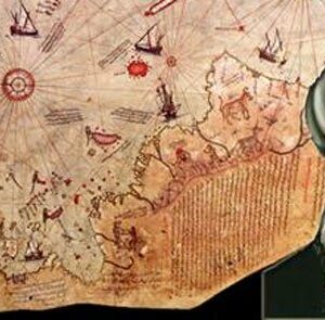
From military intelligence, he constructed a global map in 1513 that is centered on the Sahara near the latitude of the Tropic of Cancer. He gave the map to Ottoman Sultan Selim I in 1517. Only roughly one-third of the map could be retrieved.
On October 9, 1929, German theologian Gustav Adolf Deissmann’s philological studies in Istanbul’s Topkapi Palace led to the discovery of a part of the map made on gazelle skin parchment.
The map’s surviving portion depicts North Africa, the western shores of Europe, and the eastern coast of South America in detail.
He wrote on the map that it was built on the foundation of roughly 20 charts and mappae Mundi, including a map by Christopher Columbus that stated “these territories and islands are drawn on the map of Columbus,” an Arabic map of India, four Portuguese maps from Sindh, and eight Ptolemaic maps. He also claimed to have used “maps drawn during Alexander the Great’s reign” as a source.
He returned to the sea as a ship commander in the Ottoman fleet and took part in the Ottoman conquest of Egypt during the second major struggle between the Ottoman Empire and the Egypt-based Mamluk Sultanate, which took place between 1516 and 1517.
His book ‘Kitab- Barye’ was released in 1521 and contained particular navigational data as well as exact charts of the period outlining important cities and ports of the Mediterranean Sea. During the years 1524-1525, he reworked it. The Ottoman Emperor Suleiman the Magnificent was presented with a redesigned edition that included 290 maps and 434 pages.
He took part in the second effort by the Ottoman Empire to evict the Knights of St. John from Rhodes in the ‘Siege of Rhodes’. The Ottomans won the siege, which lasted from June 26 to December 22, 1522, and the Knights were forced to leave the island permanently on January 1, 1523.
He remained the captain of the ship that sailed Pargalbrahim Pasha, the Grand Vizier of the Ottoman Empire, to Egypt in 1524.
In 1528, he made a second world map, the surviving fragment of which was discovered by Tahsin z, Director of the Topkapi Palace Museum, while looking for missing pieces of Piri’s 1513 map.
The map, which is made of gazelle skin and painted in eight colors, depicts Greenland as well as North America, from Newfoundland and Labrador in the north to Cuba, Jamaica, Florida, and parts of Central America in the south.
“The map was drawn in 935 (A.D. 1528) by Hacker Piri Reis, son of Haci Mehmed, nephew to late Reis Gazi Kemal of Gallipoli,” according to the imprints on the map. The art is definitely his.” Suleiman the Magnificent received it as a gift.
In 1547, he was raised to the military rank of Reis, which translates to admiral, as Commander of the Ottoman Fleet in the Indian Ocean. In Egypt, he was also the Reis of Fleet.
On February 26, 1548, he battled against the Portuguese and captured the port of Aden in Yemen, marking the Ottomans’ retaking of the city.
In what is known as the Capture of Muscat, an Ottoman fleet led by Piri plunders the town of Old Muscat from the Portuguese in 1552. He then marched east, attempting unsuccessfully to conquer the Hormuz Island in the Persian Gulf, which is located in the Hormuz Strait.
Piri seized control of the Qatar peninsula as the Portuguese eyed the Persian Gulf, hoping to impede their plans to build outposts along the Arabian coast.
Piri returned to Egypt when he was about ninety years old. He was murdered in 1553 after denying helping Kubad Pasha, the Ottoman Vali (Governor) of Basra, in a battle against the Portuguese in the northern Persian Gulf.
Many submarines and warships in the Turkish Navy bear his name.
Piri’s Major Projects
His 1513 globe map depicts the Mediterranean Sea’s major islands, bays, ports, straits, peninsulas, capes, shelters, and gulfs in detail. It also provides information on navigation processes, facts on astronomy-related to navigation, and a general summary of each city’s and country’s people and culture.
In recognition of the historical significance of such a magnificent map, UNESCO designated 2013 as Piri Reis Year.
‘Kitab- Barye,’ his masterpiece, is considered one of the most popular cartographical works of the time.
The ‘Kitab-Bhriye’ and the surviving pieces of Piri’s two world maps are valuable historical artifacts that continue to pique the attention and research of modern historians.
Estimated Net worth
Unknown.